Drones and Utility Locating
As technology careers down the pathway of continual advancement and a component minimisation along with material weight reduction improves, the ability of locating buried utilities becomes a reality when GPR (Ground Penetrating Radar) is coupled with the use of Drones and Utility Locating.
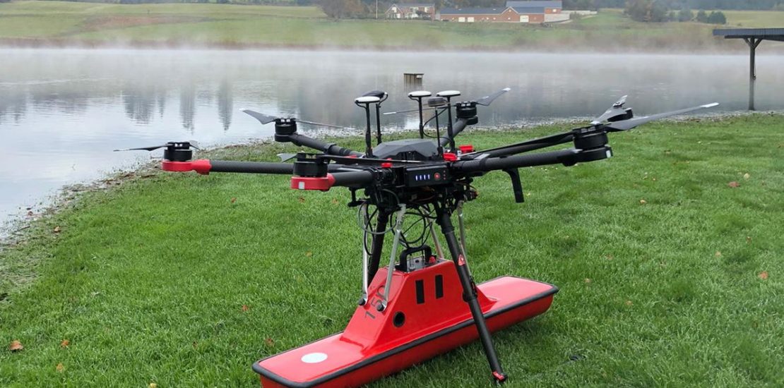
The advent of GPR technology being able to be coupled to a suitable drone, allows survey/locating technicians the ability to complete field work in areas that have been previously rated as challenging, in assessable or even dangerous. In many situations, GPR surveys are hard work and can be extremely dangerous for field personnel due to harsh topographic environments and weather conditions.
In this environment, a drone becomes an extremely efficient alternative. They are lightweight (compared to a manned airplane or a helicopter), easily transportable by car and capable of flying autonomously at low altitudes with high precision. Such an approach assures delivery of accurate survey results, is also safer for personnel and more time efficient.
Mapping of underground infrastructure is an important task before starting any construction works on previously developed territories or in cases when actual documentation and maps for underground infrastructure is missing. In sectors such as construction and utilities, a GPR drone could be used to locate underground pipes, map the conditions of the assets, and detect hazards like pipeline leaks.
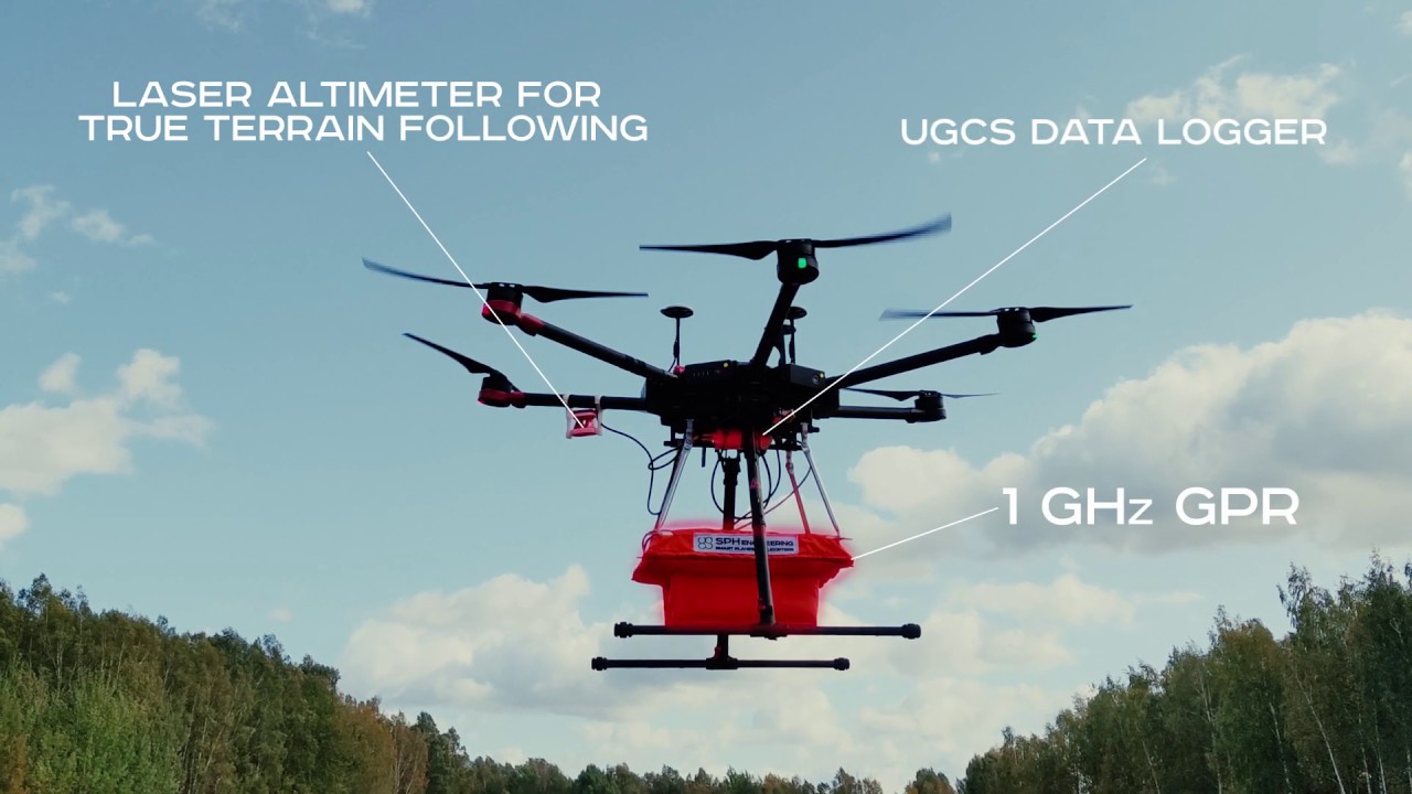
Advanced drones fly at low altitudes, close to the ground surface, and with targeted precision. For airborne surveying and inspections, this translates to better data resolution for surveying and photography. The measurements collected from GPR equipment is extremely accurate, and the documentation is high-quality. The results are equal, if not more precise, than traditional surveying methods.
Using drones, technicians can pinpoint the exact areas that they need to survey and save time reaching them. The equipment can cover even large areas and difficult topography, collecting the data required in a fraction of the time. Completing projects faster and using less invasive methods means cutting costs in the process as well.
Drone technology enables safe mapping of terrain and property. Survey technicians can now work remotely when dealing with tough conditions and difficult terrain. Working from a distance, they can send the drone into environments that would be unsafe and hazardous for manned vehicles or humans to traverse. This technology helps decrease the risk of accidents and injuries on the job and related delays.
Follow this link to a short 2-minute YouTube video: Ground Penetrating Radar (GPR) + drone to locate gas pipes.
https://www.youtube.com/watch?v=vI_gzUyMpPw
Why use GPR with drones?
As well as seeing through the surface of the ground, it can penetrate rocks and freshwater, providing an additional solution for more efficient surveying.
If you’re wondering if GPR-drones could benefit your line of work, take a look at the range of benefits this technology offers below.
• Time-efficient: Compared to traditional surveying methods, you can acquire data much faster.
• Precision: GPR-drones offer provide accurate measurements thanks to their precise rangefinder and positioning systems.
• Cost-efficient: Compared to manned flights, UAV surveys are more cost-effective.
• Accessibility: Locations which are not reachable by foot, such as ice and water, can be surveyed by drones instead.
• Safety: GPR-drones are ideal in hazardous or unsafe environments and don’t compromise the safety of your staff.
• Automated flights: Thanks to automated flight mode and an in-built GPS, the drone ensures higher accuracy when following survey lines.
Versatility
Land surveying with drone technology vastly increases the range of land access. Today, surveying crews can access areas that would have previously been impossible to cover without large, specialized equipment.
Here are a few examples of how drones are being put to work in our industry:
Land surveying,
Mapping underground infrastructures,
Thermal imaging,
Bathymetry,
Laser scanning.
Surveying busy roadways, flooded areas, or congested cities is no problem for UAVs. With GPR mounted on a drone, it’s possible to see below the surface of soil, ice, rocks, buildings and other structures. GPR-drone integrated systems can even be used to measure the depth of freshwater and frozen surfaces, or profile the bottom of bodies including lakes, ponds, and rivers.
When used for mapping underground infrastructures, construction crews will have accurate, up-to-date records of existing structures. Knowing where concrete sewage channels and tunnels lie below the surface before beginning to excavate is a valuable advantage.
Aerial surveying can deliver additional resources that are helpful in the planning and development phases. High-definition ground images and aerial views of terrain or urban areas are examples of the imaging power that drones provide.
Locating Unlimited Pty Ltd (RTO ID 45518), Australasia’s leading provider of Underground Damage Prevention Training acknowledges and supports this emerging technology and can offer the following training solutions:
• AVI30419 – Certificate III in Aviation (Remote Pilot)
• AVIY0029 – Operate rotary wing remote pilot aircraft systems
Contact Jeff at Locating Unlimited – 0419 44 66 27 or jeff.moore@locatingunlimited.com.au