EM Locator Depth Calculation
EM Locator Depth Calculation
It is surprising the number of times that I am contacted by “experienced locators” many also being DBYD Accredited, to explain the way that our EM locators calculate the depth of the utility and where that measurement is taken from.
Firstly, let me stress that it is an estimate and the only way to be 100% sure is to pothole and physically measure to the top of the service. Let me also stress that the machines depth estimate is not the depth of cover, I repeat that the depth indicated on our equipment is NOT the depth of cover, it is an estimate to the centre of the electromagnetic field, in other words the centre of the pipe or utility.
So, how does the equipment make this calculation:
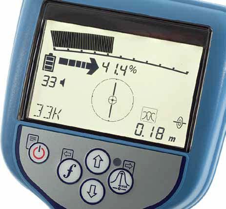
Just as two eyes enable us to judge distance, the twin aerials on quality locating instruments fitted with visual displays will give depth measurement once the conductor has been pinpointed. This is usually only applicable to an active locate, that is with the transmitter connected to the utility and a suitable frequency selected on both the transmitter and receiver, as the signal level should be at a constant level.
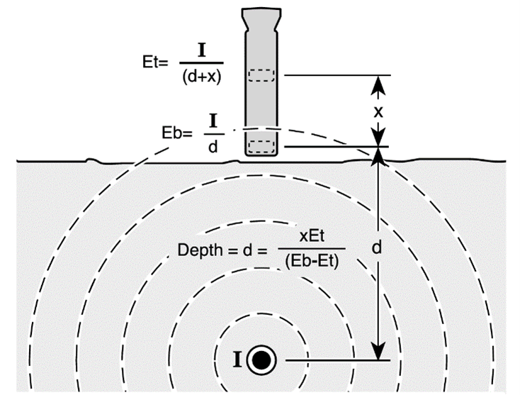
The lower Peak antennae takes a signal strength reading of the electromagnetic field leaving the buried pipe or cable. The upper Peak antennae does the same. The distance between to two receiving antennae is a fixed and known distance, and with these 3 pieces of information the equipment can calculate the depth estimate to the utility.
Accuracy may be affected by signal distortion from a nearby tee, bend, or other local interference or adjacent cables. If necessary, this quick simple estimate can be verified by triangulation. Note that the same depth estimating facility is also available with sondes. However, the different shape of magnetic field produced by the sonde means that the receiver calibration is different.
It is important that the electromagnet field leaving the utility is round when taking a depth estimate, if it is determined that the field is non round, by checking Peak and Null against each other, then action needs to be taken to change the non-round field into a round one, once you have achieved this a more accurate depth estimate can be carried out.
Caution is needed when trying to make a depth estimate near a bend in the utility’s direction of travel. For areas where the utility either bends or “tees” off, to achieve the best accuracy, Depth measurement will not be accurate, if there is notable interference or if part of the transmitter signal has coupled to a nearby line.
Locating Unlimited Pty Ltd (RTO ID 45518), Australasia’s leading provider of Underground Damage Prevention Training provides quality training solutions to industry to help maintain safe work practices around buried utilities and prevent damage to this infrastructure.
Contact Jeff at Locating Unlimited – 0419 44 66 27 or jeff.moore@locatingunlimited.com.au